 California is a state located on the West Coast of the United States. It is the most populous U.S. state,with 39 million people, and the third largest state by area (after Alaska and Texas). California is bordered by Oregon to the north, Nevada to the east, Arizona to the southeast, and the Mexican state of Baja California to the south. It contains the nation's second most populous census statistical area (Greater Los Angeles Area) and the fifth most populous (San Francisco Bay Area), and eight of the nation's 50 most populated cities (Los Angeles, San Diego, San Jose, San Francisco, Fresno, Sacramento, Long Beach, and Oakland). Sacramento has been the state capital since 1854.
What is now California was first settled by various Native American tribes before being explored by a number of European expeditions during the 16th and 17th centuries. It was then claimed by the Spanish Empire as part of Alta California in the larger territory of New Spain. Alta California became a part of Mexico in 1821 following its successful war for independence, but was ceded to the United States in 1848 after the Mexican–American War. The western portion of Alta California was organized as the State of California, which was admitted as the 31st state on September 9, 1850. The California Gold Rush starting in 1848 led to dramatic social and demographic change, with large-scale immigration from the east and abroad with an accompanying economic boom.
California's diverse geography ranges from the Sierra Nevada in the east to the Pacific Coast in the west, from the redwood–Douglas fir forests of the northwest, to the Mojave Desert areas in the southeast. The center of the state is dominated by the Central Valley, a major agricultural area. California contains both the highest point (Mount Whitney) and the lowest point (Death Valley), in the contiguous United States and it has the 3rd longest coastline of all states (after Alaska and Florida). Earthquakes are common because of the state's location along the Pacific Ring of Fire. About 37,000 earthquakes are recorded each year, but most are too small to be felt.
California's economy is centered on technology, finance, real estate services, government, and professional, scientific and technical business services; together comprising 58% of the State economy.Although only 1.5% of the State's economy, California's agriculture industry has the highest output of any U.S. State. If it were a country, California would be the 8th or 9th largest economy in the world and the 34th most populous.
California is home to nearly 11 million people who were born abroad;over a quarter of the American total.California is the 3rd largest state in the United States in area, after Alaska and Texas.
In the middle of the state lies the California Central Valley, bounded by the Sierra Nevada in the east, the coastal mountain ranges in the west, the Cascade Range to the north and the Tehachapi Mountains in the south. The Central Valley is California's agricultural heartland.
Divided in two by the Sacramento-San Joaquin River Delta, the northern portion, the Sacramento Valley serves as the watershed of the Sacramento River, while the southern portion, the San Joaquin Valley is the watershed for the San Joaquin River. Both areas derive their names from the rivers that flow through them. With dredging, the Sacramento and the San Joaquin Rivers have remained deep enough for several inland cities to be seaports.
The Sacramento-San Joaquin River Delta is a critical water supply hub for the state. Water is diverted from the delta and through an extensive network of pumps and canals that traverse nearly the length of the state, to the Central Valley and the State Water Projects and other needs. Water from the Delta provides drinking water for nearly 23 million people, almost two-thirds of the state's population as well as water for farmers on the west side of the San Joaquin Valley.
The Channel Islands are located off the Southern coast.
The Sierra Nevada (Spanish for "snowy range") includes the highest peak in the contiguous 48 states, Mount Whitney, at 14,505 feet (4,421 m). The range embraces Yosemite Valley, famous for its glacially carved domes, and Sequoia National Park, home to the giant sequoia trees, the largest living organisms on Earth, and the deep freshwater lake, Lake Tahoe, the largest lake in the state by volume.
To the east of the Sierra Nevada are Owens Valley and Mono Lake, an essential migratory bird habitat. In the western part of the state is Clear Lake, the largest freshwater lake by area entirely in California. Though Lake Tahoe is larger, it is divided by the California/Nevada border. The Sierra Nevada falls to Arctic temperatures in winter and has several dozen small glaciers, including Palisade Glacier, the southernmost glacier in the United States.
About 45 percent of the state's total surface area is covered by forests,and California's diversity of pine species is unmatched by any other state. California contains more forestland than any other state except Alaska. Many of the trees in the California White Mountains are the oldest in the world; an individual bristlecone pine is over 5,000 years old.
In the south is a large inland salt lake, the Salton Sea. The south-central desert is called the Mojave; to the northeast of the Mojave lies Death Valley, which contains the lowest and hottest place in North America, the Badwater Basin at −279 feet (−85 m). The horizontal distance from the bottom of Death Valley to the top of Mount Whitney is less than 90 miles (140 km). Indeed, almost all of southeastern California is arid, hot desert, with routine extreme high temperatures during the summer. The southeastern border of California with Arizona is entirely formed by the Colorado River, from which the southern part of the state gets about half of its water.
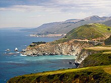
Along the California coast are several major metropolitan areas, including the Greater Los Angeles Area, the San Francisco Bay Area, and the San Diego metropolitan area.
As part of the Ring of Fire, California is subject to tsunamis, floods, droughts, Santa Ana winds, wildfires, landslides on steep terrain, and has several volcanoes. It has many earthquakes due to several faults running through the state, in particular the San Andreas Fault.
No comments:
Post a Comment